


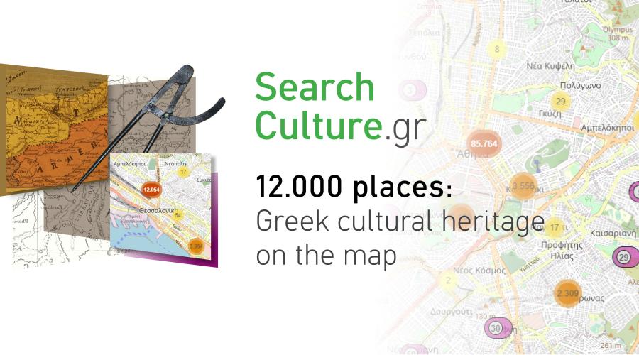
In the new edition of EKT’s National Aggregator of Digital Cultural Content, SearchCulture.gr, Greek cultural heritage is put on the map.
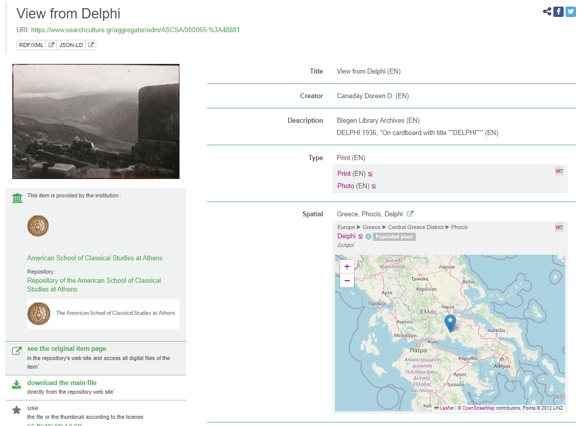
Mining the geographical information that accompanies the documents, EKT has indexed 12,000 geolocations associated with Greek culture, and more than 550,000 records were enriched with geolocation data. Location is now a searchable field on the SearchCulture , with the results being displayed on interactive maps, where users can find items at village, town or monument level. At the same time, places also act as a filter for results. From the Places navigation page the user can see the two hierarchical vocabularies created by EKT, while in each item record, a smaller map shows the geographical location of the cultural resource.
Added value
The curated interactive heritage map of SearchCulture.gr gathers and presents vast amounts of information in accessible formats.
The extraction of information does not only concern the material heritage as the map also shows all the elements that make up the expanded ‘cultural landscape’ of Hellenism. Thus, the places that cultivated the traditional arts, the places of worship and prayer, the routes and trade between places, various aspects of intangible heritage, such as sayings and proverbs - many of which may not be associated with places that are considered historical, but illuminate the socio-spatial dynamics of Greek culture, are highlighted.
Maps were the primordial, the first visual ‘language’ of people, long before writing. They help to better understand how natural and man-made landscapes interact and are shaped.
For SearchCulture.gr users, maps offer a dynamic and contemporary way of immersion and engagement with our history and culture, broadening perspective and facilitating understanding of the past.

Use cases
Users can search in the search box for a location entering its name, taking advantage of the autocomplete function of the new Place field. The results of his search are displayed either on a grid or on a map and can be filtered using the facets. For those who want to explore the content in a more structured way, the list of places in SearchCulture.gr corresponds to the two bilingual Vocabularies of geographical names Geonames.
Alternatively, the user can freely navigate the interactive map, focusing on the area of interest. Alongside each item that has been enriched, there is a map with its geolocation. By combining filters, such as dates or subjects, the dispersion of records on the map emerges, as for example by selecting the Historical Period ‘Hellenistic Period’ one sees the dispersion of content on the map. Otherwise, the user can explore the content topics, e.g. ‘Asia Minor Campaign’, to locate items with this subject on the map of Asia Minor. Another way to explore is by selecting a personality from the persons page, e.g. Alexander the Great. The results depict his life on the map through testimonies related to him.

Finally, users can see the collection of an institution on the map, where the coverage and dispersion of its material is displayed. An example is the collection of the Jewish Museum, which, through the map, indicates the Jewish presence in Greece and beyond.
Those who are interested can refer to the updated SearchCulture.gr User Guide or the help page to see in detail all the ways to navigate and search.
Placing items on the map
SearchCulture.gr scientific team carried out extensive curation of the content so that the geographical information could be homogenised and could be used for geospatial discovery. Advanced semantic information representation technologies were used, open geospatial databases were exploited and appropriate geospatial data visualisation methodologies were developed.
The enrichments were made on the basis of the primary documentation of the institution. The geographical information is usually captured in the field ‘geographical coverage’. This is a broad field that can record either the place where an item was created; the place where it was published; the current place where it is being kept or even its subject-matter. If this documentation was not available from the institution, the geographical information was extracted from the title of the records, the subject and sometimes from the digital representation of the object itself, if the information was recorded.
The items were enriched with the new field ‘EKT Place’ with references to terms of a bilingual hierarchical vocabulary of places that was developed and which is the Greek version of selected terms from the geographical database GeoNames and a complementary bilingual vocabulary with historical or non-administrative areas.
The open GeoNames database, which is developed by data contributed by users, is probably the most important open geospatial database. The supplementary EKT vocabulary was created to fill certain gaps identified in Geonames, for example historical areas (e.g. Phrygia, Lydia, etc.), areas that include many different states or geomorphological elements, such as rivers, lakes, etc. which do not appear within the borders of a single State and do not correspond to the administrative hierarchy of the basic vocabulary.
Summing up, in order to launch the new functionality:
- 12,000 terms were included in the Places Vocabulary
- >20,000 matches were made for >28,000 unique values
- 550,000 items were enriched with geolocation.
Combining historical, spatial and cultural narrative into interactive maps completes a five-year cycle of semantic curation of the aggregator's metadata, which has established SearchCulture.gr as one of the most organised and user-friendly national digital content aggregators in the world.
Challenges
During the implementation of the new functionality, methodologically, each collection was treated according to its specifics.
If the institution used the special field ‘geographical coverage’, the enrichments matched this information with a vocabulary term. The challenges involved clarifying terms, especially in place names often found in Greece, such as Kastania, Agia Anna, etc. Another challenge was the difficulty of identifying Greek exonyms with the corresponding endonyms, i.e. the names by which a people calls the places they live. For example, the term "Plovdiv" is an exonym for Philipoupolis, Bulgaria.
Finally, there were also the cases of multiple locations linked to one item. In correspondence, for example, it is customary to document both the place of dispatch and the place of origin, so we have two geolocations for one item.
There are cases where entire temple systems were dismantled and transferred to another location for restoration or prevention, such as those of Abu Simbel and Kalambsha in Egypt. The original documentation placed them in the old location, whereas today they are in a different place. Methodologically, this issue was addressed on a case-by-case basis, assessing the role and type of geographical information for each collection of the aggregator.
The palimpsest of place names
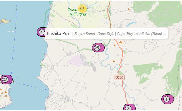
Some sites, especially in the Mediterranean basin, have been inhabited continuously from ancient times to the present day. Through centuries-old spatial stratifications they form a palimpsest of names, timelessly made meaningful by people and the landscape. The process of capturing in semantic terms the historicity of a place was of particular concern to the SearchCultur.gr team during the enrichments. Geonames basically use modern Turkish or Arabic place names, and often not in Latin characters, so research had to be carried out to link ancient sites with modern ones wherever possible.
In some collections of historical-geographical interest - such as the Travelogues of the Laskaridis Foundation - the challenge was to identify a location with a specific point on the map, based on the previous ‘analogue’ identification through description and the depiction drawn by hand by the traveller 200 or 300 years ago.
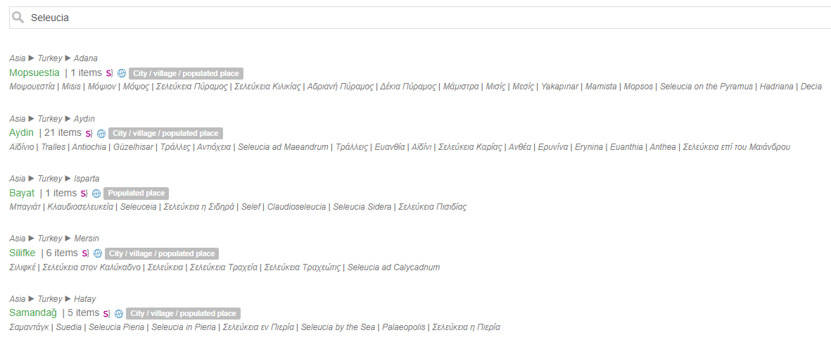
Thus, an attempt was made to semantically unify the histories of places in the place names of the Vocabulary, gathering the successive rewritings of the place through time as Alternative Names and making them searchable. Therefore, for example, if someone is looking for items concerning Seleucia, because they probably do not know the current Turkish place name, the search will retrieve all the locations with the older name ‘Seleucia’, i.e. Seleucia of Caria, Seleucia on the Pyramus, Seleucia of Pisidia, Seleucia of Isauria and Seleucia of Pieria, which in Turkish are respectively Aydin, Misis, Bayat, Siflike and Samandag.
Interaction and visualisation
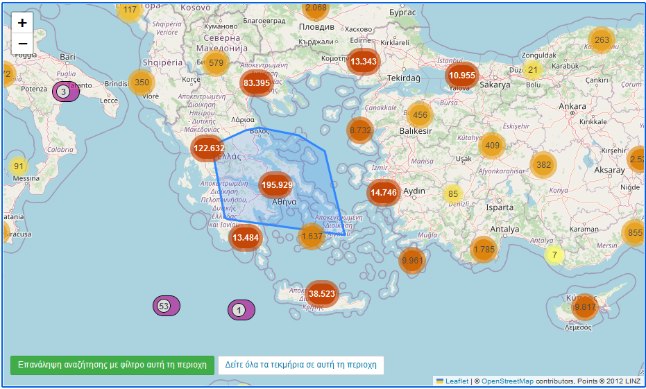
Particular emphasis was placed on the use of geospatial data in visualisations. To this end, the open maps of the OpenStreetMap community were used. Due to the large amount of data, the results appear grouped in clusters (visualised as trapezes). One can see the items distributed in the respective geolocations. Yellow, orange and deep orange show groups of items in nearby geolocations, while purple depicts single records relating to a location.
The playfulness of map-based discovery and the interactivity of navigation add value and increase accessibility or the user. Through the maps, one understands visually the expanse of places that Hellenism touched in some way, as well as the density of records in one particular location.
In order to enable search for items based on the geospatial coordinates of the locations associated with them and apply the geospatial search capabilities offered by the indexing system used by SearchCulture.gr, the open source Apache Solr software was used. All locations of the two vocabularies are associated with the corresponding place names of the geospatial database geonames.org from which the coordinates were derived.
Displaying thousands of items on the map has been a major challenge, both in terms of user experience, system response, computing resource and memory requirements. On the one hand, the number of different locations that appear in the results of a search can be very large (potentially more than 12,000), on the other hand, a very large number of items can be ‘placed’ in each location. To address the problem, the clustering method was followed: the user does not see all the different locations at the same time but a ‘cluster’ that can be further expanded as the user clicks or zooms on the map.
The implementation of the map navigation was based on the javascript library open source leaflet.js, while for the map, OpenStreetMap.org, a freely licensed map developed by a community of volunteers who contribute and maintain geospatial data, was used.
About SearchCulture.gr
SearchCulture.gr is the National Aggregator for Digital Cultural Content and the accredited national aggregator for the European digital library Europeana. It collects the metadata and preview images of the digital cultural resources from the websites and repositories of the participating organizations and publishes them enriched in the Search Portal.
The upgrade and expansion of the SearchCulture.gr aggregator with new functionalities is carried out by EKT within the framework of the act ‘National Information System for Research and Technology: Infrastructure for the Aggregation, Documentation and Dissemination of Digital Content ensuring interoperability, long-term preservation and open access’. The operation is being implemented under the Operational Programme ‘Public Sector Reform’ (NSRF 2014-2020) and is co-funded by the European Union - European Regional Development Fund and national resources.

Links
Related News
-
 02.10.2025
 -
 17.09.2025
 -
 09.10.2023
 -
 04.07.2023
 -
 28.06.2022
 -
 28.03.2022
 -
 Distinguished Persons in Greek History and Art: a new way of discovering content on SearchCulture.gr18.01.2022
 -
 15.07.2020